This wonderful article was written in Russian by Alex, with photos by Busro(“undergroundfoto”). Their fundamental research on the subject of Moscow’s water supply is sure something worth translating. A lot of text & underground exploration photos.
You can check out their blogs for more other texts and photos:
http://alex-avr2.livejournal.com/
http://undergroundfoto.livejournal.com/
Hope you enjoy it! ~9andvodka
A short foreword
This article was prepared for as much as three years. I found the first brick water supply gallery in 2006. Back then I didn’t know what it was, and ignoring the fact that it had brick walls, I didn’t even try to go down, and was satisfied by the view from the manhole. As time passed, I got to know Moscow’s underground a lot closer, and at some point I recalled the brick arcs I saw three years ago. By that time I realized the value of historical brick facilities, and decided to investigate the gallery immediately. I went down in March, 2009. Due to certain circumstances, I can’t say that I was really impressed by what I saw – but it was an old brick tunnel, and such a finding was pleasant. I didn’t understand which system it belongs to, and had no overall understanding of Moscow’s water supply system’s functioning. But the subject sure interested me, and the farther I researched, the more I made amazing discoveries. That sequence of discoveries is still going on and on.

The people
Before I start my story, I want to tell about the people involved
It is, of course, undergroundfoto, with whom we’ve been on most of the trips outdoors and in search for information. Most of the photos in the article are his. Full sets of the photos taken during our investigations can be viewed in his blog. I couldn’t have done it alone, so it is no less undergroundfoto’s merit in preparing this article as it is mine. (UPD – some links – The Moskvoretskiy water supply tunnel, Delvig water supply tunnel)
Komandir, Pila_dotoshnaya, Kreazot_13 – I promised to tell you the secret of the egg-shaped tunnel near Victory park. The time has come!
And special greetings to Kreazot_13, a big fan of all that’s old and brick. There’s a lot of that in the article.
There are some other people that helped in our research at some point, but that better not be mentioned here. Also huge thanks to them!
The research
I should firstly tell more about the subject of our studies. We explored all underground and little known facilities of the old water supply systems. There are a lot of texts on the subject online, and a lot of them are worthy, but they all tell the general theories, not mentioning the details of underground constructions. Moreover, they speak of the historical Moscow water supply system as of something gone long ago (excluding the well-known aboveground buildings), but it isn’t true. A lot of the facilities still remain underground, in one state or another.
We were interested in the remaining facilities, especially in brick galleries. I should note that we weren’t exploring only the water supply system all the three years in a row. The research was performed spontaneously and briefly, and then was put aside for several months. It was decided not to publish any intermediate results and findings, not to raise the topic and attract other “researchers”. With all the numbers of urban explorers in Moscow, the paradox is that nobody has ever shown serious interest in the water supply system. Few mentioned attempts to search for brick galleries, but didn’t really succeed. We may assume that someone might be performing a similar research or has already accomplished it, and for some reason doesn’t share his results, but we were sure the first visitors over the last few years in some of the tunnels, so that probability is minimal.
As the explorers in Samara say, theory and practice are inseparable in exploration. Some Moscow explorers may argue about that and say that practice is enough to get in. It isn’t so in case of the water supply system. The complexity consists in the fact that all tunnels of the historical water supply are quite old. The “youngest” tunnel in the article below is 110 years old, and some are over 200. The tunnels have severely changed during these two centuries. The surface above and near them has also changed beyond recognition. Where there once was a field, there is now a densely populated neighborhood with a metro line. In some places there were ditches dug, and the old tunnels were destroyed. Some manholes were covered or buried; some tunnels got filled with sand or clay. Other manholes turned out to be on a six-lane highway. All of this made the search of old tunnels really difficult. Although it’s possible to find a few manholes by chance, no serious research can be possible without a strong theoretical basis. And even then, having a perfect map, locating the tunnel is a difficult task. The bare statistics should be most expressive:
-Total trips in Moscow & city suburb (mostly in company of undergroundfoto): around 25-35
-Total walking distance: Over 100 km, exact number is unknown
-Total manholes opened: Over 100, exact number is unknown
-Galleries found (whose existence and actual location is known exactly): 13
From which, explored completely: 5
Explored partially: 1
Entrance found, but can’t be explored from above for some reasons: 2
No trace found on the surface, but should exist below ground: 2
No trace found on the surface, probably demolished: 1
A thorough search not performed due small probability of result: 2
-Culverts found (whose existence and actual location is known exactly): 7
Of them, actually located: 5
Not found: 1
Demolished: 1
-Hours spent at the computer in search and systematization of information, topographic location etc.: incalculable
The format of the article
I hesitated to choose the right format of the article. On one hand, I thought of writing it with the approach of the local historian, which is to disclose all the information we managed to find, with all particular details, with all the names and coordinates. On the other hand, this totally contradicts the main principles of exploration, which encourage not revealing neither the location, nor the exact function of the place on a published photo. In the end, I picked something between the two. If you wish to make any additions or ask a question, you can do that in the comments.
I guess I bored you enough with introductions; it is time to pass to business.
It will be about two water supply systems. Mytishinskiy – the oldest water supply infrastructure, and Moskvoretsky – a newer and bigger one (translator’s note – the difference between the two is the water source – the first being north from the city, and the other – west). The present-day inhabitants of Moscow take the water supply for granted, but 200 years ago, it was not the case. There were no water pipelines, but water was needed no less than today. Water was taken from the local rivers, which, as a matter of fact, served as well for the purposes of sewage (by the way, the sewage system was not as fortunate – it’s construction started only 125 years after the first water supply system was launched), and the water in wells was not much cleaner either. The issue of water supply was serious back then. In the last 230 years, the system has continuously evolved and turned into a complicated structure that provides water for millions of the city’s inhabitants.
Mytishinskiy water supply infrastructure
The construction of Mytishinskiy water supply infrastructure started in 1779, during the reign of Queen Catherine the Great. It was the first water supply tunnel, and concurrently, the first communal tunnel in Moscow. Subsequently, the infrastructure was rebuilt completely twice, each time nearly from scratch. So actually we can say that we have three separate systems. They all head from the town of Mytishi to the very centre of Moscow, each around 27 kilometers long, with a total length of 80-100 km. This map shows the tree different tracings of the water supply from Mytishi to Moscow.

By now, on most of its extent, it is on the territory of the city. Back then, Moscow was small, and the pipeline went through fields and forests. Afterwards, residential areas and factories were built right on top on the tracks. In the case of rivers put below surface, their oldest parts usually remain untouched under roads, but in this case, the pipeline of water supply went right through the sleeping areas and industrial zones. If you happen to live in the northeast of Moscow, it may be possible that your house stands on remnants of an old gallery built by the order of Queen Catherine herself.
The Mytishinskiy water supply tunnels were completely abandoned in 1960. The old pipes were not functioning by that time, and the water was probably used to supply the northeast of the city. Let us have a detailed look at all the three parts of the Mytishinsky water supply infrastructure.
Queen Catherine’s water supply infrastructure
Queen Catherine was first to come up with the idea of water supply infrastructure. According to the legend, she was traveling somewhere along the road to Yaroslavl and stopped at the town of Mytishi. The queen was given some water and she liked it so much, that she ordered the construction of a water supply system to transfer water from Mytishi to Moscow. Nevertheless, whatever the legend was, they did decide to build the system. A famous engineer of that time, Friedrich Bauer, was assigned responsible for the designs and construction. The water supply system was designed to be gravity flow from Mytishi to Moscow. It was not likely to have any other project those days, though now all water supply pipes are pressure pipes. Such a design would have then been too difficult to make and expensive. There were no pipes or pumps that could create the required pressure, and steam engines were just beginning to appear in practical applications. The channel was build from brick, and since it was gravity flow, it had to have an incline on all its way to Moscow. The construction started in 1779, and the first water ran down in 1804. Let us just move on to the specific details of the buildings.
Special wells were built on top of springs in Mytishi, they gathered the water and transferred it into the channel. There were 40 of them, each of a different size. One of the wells is displayed on the picture below.

The channel had a rather recognizable shape. The inside was an arch 90 cm wide and 135 cm tall, the walls were supported with wooden beams. The ceiling was relatively thin. The decision to build the gallery on wooden beams the came from the assumption that wood does not rot in water. However, this assumption turned out to be fatal for the gallery.
After collecting all the water from the Mytishi springs, it made a small loop around the town and headed to Moscow in a nearly straight line. I haven’t seen the exact designs of the complete track of the gallery on all of its length, but I believe that they could be found if necessary. The water supply crossed several rivers. Aqueducts were built on these intersections, looking somewhat like the ones in ancient Rome. Most of these rivers are now underground, the aqueducts are covered or demolished, but one remains. It’s the Rostokino aqueduct. The water supply crossed the Yauza River twice – the first time near the gallery’s beginning in Mytishi. There the intersection was implemented as a siphon of the two iron pipes passing under Yauza and with brick pools on either side of it. Water flowed from one to the other according to the law of communicating vessels. The second intersection was near the village of Rostokino. The Yauza River was bigger there and flowed in a rather deep ravine, so they couldn’t have gotten away by making a siphon and built an aqueduct instead.

This aqueduct survived to this day. To my surprise, many Muscovites have never heard about it, even though it is in 15 minutes of walking from the VDNH metro station. Moreover, most of the people that know about it have no idea of its purpose and why it was built. Now the aqueduct is no longer used for its intended purpose, and serves only for decorative functions. It was renovated a few years ago and now looks like new. Illumination was installed, and a footpath was made on top. I recommend anyone who has not seen it yet to go and have a look; it is a wonderful place at daytime and night likewise. Before the renovation, the aqueduct was in quite a bad state. In the late Soviet time, it had central heating pipes going on top of it.
However, let us go back to the gallery. After the aqueduct, it headed towards the city centre, but at some point turned east and crossed the Sokolniki park. From there the gallery headed towards the central streets of the city, and surfaced in several water supply fountains. The initial plans were much bigger, but they never came true. Quote:
The water was supposed to flow by gravity into pools from Kalanchevskaya Square to Elokhovo and the German settlement, and be lifted up to the Basmannaya, Miasnitskaya and Meschanskaya neighborhoods with the power of the fire engine. A pool should have been built on the Trubnaya square. A pipeline with 450 mm cast iron pipes should have been built from there along the River of Neglinka, and construct: A reservoir with pure water on Sandunovskaya square, two pools on the Kuznetskiy Most, a few before Tverskaya Street, and make a channel after the Voskresensk Bridge, for purposes of decorating the city. The water supply for Tverskaya, B.Dmitrovka and Nikitskie Gates was intended to be made from a reservoir installed on a tower near the Troitsky Bridge. The water was designed to be lifted by a pump that was supposed to be set in motion by the current of the Neglinka River. A reservoir with a lock was to be built on the Samotechnaya square, for the purpose of flushing the open Neglinka channel. The channel’s width was designed to be 6.4 meters. It was supposed to end by the Troitsky Bridge. […] The project was actually performed partially, in bringing water to the reservoir at Trubnaya Square and feeding several water fountains. The proposals of supplying water to several other areas at a higher level with a fire engine were not implemented.
A few months later we managed to get more detailed information. Some parts of the water supply infrastructure could be traced quite exactly on the contemporary landscape. By this, I mean that the precision was some tens of meters. This part was outside Moscow, near the town of Mytishi, where the old water supply gallery commenced. However, we were disappointed after reaching the actual location. After walking a kilometer back and forth on the alley, we saw practically no sign of the gallery. As if it had never been there. The area had severely changed over the years and became swampy. Even if the gallery remained before the place turned into a swamp, it had no chance of surviving this. Even no trace of the reservoirs on top of the springs remained. Or maybe we can say that just the traces remained, but not the pool buildings themselves. For example, this rectangular ditch exactly matches one of the pools on the map.

Apart from this, we found a bridge over a local stream. The bridge looks modern from above, but if you look below you can see the brick base. The bridge was marked on the plans of Queen Catherine’s water supply infrastructure, but we can’t be absolutely sure that the bricks remained from that time, but I am convinced that they are.

The attempts to find Queen Catherine’s gallery in the town of Mytishi failed as well. No remnants were found even in the places where the gallery could be traced quite precisely. However, this article wouldn’t have been written if we didn’t manage to find a part eventually. A few days before publishing this text, we managed literally to find the needle in the haystack, which is a fragment of the gallery in Moscow. It wasn’t found by chance, but as a result of a long and precise calculation. When undergroundfoto and I reached the place, we found the manhole immediately. It was a surprise and delight, when we opened it and saw a brick gallery!

The gallery turned out to be soiled up to the very ceiling. That was expected, since we’ve been to such places before, so we were not surprised. I went down and was surprised to see that the tunnel ends in a few meters in both ways.

On one hand, the length of this fragment was a disappointment. Such a small clearance would have given us enough room to crawl if the gallery continued further. On the other hand, there was this funny feeling that we managed to get into a really small fragment, and it wouldn’t have been possible if it was in a few meters either direction.
If I knew beforehand that this little fragment is all that we can find of Queen Catherine’s water supply infrastructure, the oldest underground service tunnel in Moscow, I would have been seriously upset. Now, having spent loads of time searching, I understand that even this small part is a big fortune! Quite possibly, there are other fragments, and probably they might be accessible. They are not easy to find, but I hope that one day someone will manage it. Alternatively, if it was possible to approach the issue more thoroughly, not look for manholes and just make a small archaeological excavation.
The story of Catherine’s water supply infrastructure is over. You must have gotten tired of indistinct photographs and big texts. There will be less text and more photos of wonderful tunnels from now on! 🙂
Delvig’s water suppy infrastructure
The galleries of Queen Catherine’s water supply were collapsing; so it was decided to build a new infrastructure (translator’s note – Alex didn’t mention the fact that the wooden floor that was supposed to be preserved in water started to rot – which not only caused the destruction of galleries, but also spoiled the water’s taste). Unfortunately, I don’t have much information about the infrastructure in the first half of the XIX century. It is known that a steam engine was installed at the Alexeevskoe village (now a same-named district and metro station) during the reconstruction in 1826. The last part of the water supply, from Alexeevskoe the city centre, was rebuilt; cast iron pipes replaced the gallery. It was a pressure system, so the pipes were put in a straight line and could go higher or lower, and didn’t zigzag like the old gallery. The fountains at Sukharevskaya, Lubyanskaya, Teatralnaya and Voskresenskaya Squares and Varvarskie Gates appeared at the same time. Some of them remain till nowadays, but then their purpose was utilitarian – they used to supply the city with water. The fountain on the Revolution square is still there and serves utilitarian functions – but of another kind (translator’s note – the place is the one called Voskresenskaya Square before the revolution. It now serves as a metro shaft). Now, only the most marginalized inhabitants use fountains as a water source. However, back then it was the main source of pure water.
In the 1850’s it was decided to upgrade the infrastructure once again and transform it into a pressure system on its entire length. The construction was entrusted to Andrey Delvig, a military engineer. During the years 1853-1858, a water lifting station was built in Mytishi and a 20-inch pipe (50 centimeters) was installed throughout the network’s length. It is rumored as if the pipes were put right into the old gallery of Queen Catherine, but it isn’t true. The pipe crossed the old system in several places and didn’t even go over the aqueduct in Rostokino. Unfortunately, there isn’t much information available on Delvig’s water supply system, much less than on other water supply networks. Therefore, we can only assume some specific parts of the design. For example, we don’t know if the pipe was put in soil on all of its length on all its length or if brick galleries were built in some parts. At least one fraction of the water supply system remains to the present day. It is a brick tunnel that used to hold the pipe. It can’t be seen now – it was either removed or covered by a thick layer of sand. This sand doesn’t allow us to consider the full scale of the tunnel, but nevertheless it is tall enough to walk in full height.
A nice domical shaft leads into the tunnel. It is covered by a huge stone manhole. Unlike Queen Catherine’s water supply gallery, due to some reasons, the original manhole survived.

More photos by undergroundfoto available in his blog
At the same time, the Gromovoy spring was built, or, better to say, the structure on top of it.

It was not only aboveground, it had an underground part.
Pool №1 (Gromovoy) is a round construction 7.5 meters in diameter, the walls of which are 1.3 meters below ground. Above ground the walls are covered with a dome, which has a barred hole in the centre. The pool below the dome is made of stone and is 5.3 meters in diameter and 1 meter deep, walled with cast iron grate.

More information on the topic is available on the given link. Unfortunately, there is no trace of the structure remaining now – there is only a muddy field and a modern sewer pipe.
Zimin’s water suppy infrastructure
In 40 years time, the water of Delvig’s network was once again not enough for the city. Moscow was growing, and the pipeline was decaying. And once again it was decided to build a new water supply network. This time the construction was entrusted to engineer Nikolai Zimin. By the way, he was a graduate of Imperial Moscow Technical School, now called the Bauman Moscow State Technical University, and this is where I studied too (me too! ~9andvodka). Zimin approached the issue radically, and the entire water supply infrastructure was rebuilt during years 1880-1892. This time, two cast iron pipes were put, 26 inches (62 centimiters) wide. The water-lifting station in Mytishi was rebuilt, new pumps were installed. The water-lifting station in Alexeeveskoe was also rebuilt, and new water towers were constructed near the modern Rizhskaya station. This reconstruction gave the city many beautiful buildings, most of which have unfortunately not survived until nowadays. The most remarkable of them were sure the Krestovskie towers on Rizhskaya.

I think that if they would’ve remained, they could have been one of the most famous city structures, or even a symbol of the city in some cases. Unfortunately, they were destroyed in 1940, during the expansion of the Yaroslavl highway.

However, the building of Alexeevskaya water-lifting station survived. Right now it is on the territory of a decaying factory called Vodopribor, and it’s possible to see the building only by looking over the fence.

But let’s return to the underground. Pipes of the third Mytishi water supply were put in the soil, but nevertheless, brick tunnels of different length were built in some places. Unfortunately, we couldn’t explore them completely, but I do not leave hope. Some entrances are covered, in other places the tunnels are flooded. The tunnel on the picture is soiled and flooded to the ceiling. You can see the two pipes of Mytishi’s water supply.

Unfortunately, this tunnel can’t be explored. Only the round brick room where it starts is accessible. It is full of tangled pipes and valves. The pipes are the only thing you can stand on, having over a meter of ice-cold water below you. By the way, the pipes were made in the Russian Empire, but the valves were bought in England.

I must note the room’s unique atmosphere of antiquity. The candle-lit brickwork, valves, decaying pipes, and the black mirror of the water surface carry you a hundred years back. No picture could express that 🙂
Anyway, the tunnels were not only built for pipelines. If the trail of the water supply crossed some small river, then aqueducts or bridges were built, and in some cases the river was put in a tunnel. Just as Queen Catherine’s water supply system, Zimin’s water supply crossed the Yauza River twice. On one of the intersections, they used the old aqueduct in Rostokino, but constructed a building on one of its ends. It remains at the southern part of the aqueduct, now occupied by some construction firm. But the crossing near Mytishi was designed in the form of a bridge. Although it is in a bad shape, it is still stands there. You might not notice that it’s part of the old water supply system when you walk by, but an expert can point out a sign of respectable age, the riveted sheets of metal

The bridge was noticeably modified; the brick supports were enforced with concrete, the top is paved with regular concrete slabs, railings added. There are some pipes inside, but they look more contemporary. Originally, the bridge looked like this:

There also was an aqueduct over the Ichka River. It survived until 1997. It was destroyed during the construction of either the Moscow ring road, or the Yaroslavl highway. There is no trace of it now, and only one photo remains.

You to see the similarities photos with the drawings.

And in some cases, it was easier to put the river in a tunnel than build an aqueduct. Thus, for example, a collector was built for a nameless river. Explorers call its form “egg-shaped”, which, scientifically, is ovoid.

The funny thing is that undergroundfoto and I found this egg accidentally and independently from our water supply research. We didn’t understand why might there be a brick tunnel. Brick tunnels were built before the 1920-1930’s, and only in densely populated areas. Considering the years, this part of the city could not anyhow be called the city centre. It was only in a few months after the discovery of the sewer that we understood why it’s there.
I would also like to note that although the third Mytishi water supply system is less studied than the other two, there are still some blind spots. Some tunnels were not found, although their existence is known for sure, and part of them ought to be interesting and not standard. Unfortunately, all attempts to find them were unsuccessful. I hope one day we will be lucky, and they will be explored, one way or another.
For now, let’s proceed to the Moskvoretskiy water supply infrastructure.
Moskvoretskiy water supply infrastructure.
The history of The Moskvoretskiy water supply infrastructure is, of course, closely related to that of Mytishi.
It is in the nature of man to extract more and more from the earth, just as the amount of water retrieved from the ground increased after every reconstruction. During Queen Catherine’s times, the water was flowing out of the ground freely, wells were made during Delvig’s times, and finally, Zimin used electricity to extract water. Special filtering pipes were hammered into the ground in the area of the spring. The water was technically pumped out of the ground. This played a key role in the decease of the Mytishi water supply. Irreversible processes of the hydrological regime began, and the once-pure water turned into a muddy liquid. Moscow was still growing and the water was once again running short, while its quality drastically decreased. A new water source had to be found.

Technology has considerably advanced during the 120 since the creation of the first water supply system. The so-called English (or the slow) filters were invented. Steam engines became widely used, and powerful electric motors were to come soon. There was no more need to use spring water and gravity flow tunnels, technology allowed to take water prom the river, purify and lift uphill, and that was exactly what was done. This is how the Moskvoretskiy water supply appeared. The designs were done by the same Zimin, who participated in the development and construction of Mytishi’s third water supply. That’s why the last Mytishi and the Moskvoretskiy water supply infrastructure have a lot in common.
I’d like to mention that The Moskvoretskiy, now called the Roublevsky water supply system still functions, and moreover, is the main water supply in the city. Of cource, the water does not flow in the same pipes and galleries of the first Moskvoretskiy water supply system – they have decayed and couldn’t possibly hold the water pressure. The pipes have been replaced numerous times, and the water intake station was extended and rebuilt. The water supply network of Moscow had also changed drastically, but I’ll keep that for later.
The Moskvoretskiy water supply system started in Roublevo, at the water intake station. The location was chosen well – the Moscow River was still clean there, since the city was on a large distance. The first water intake facility still remains, but is within the premises of the station, so it can only be seen from the opposite river bank. An old photo is given below. It looks quite the same nowadays.

The water supply headed to the Vorob’evi hills (“Sparrow hills”), where a big reservoir was located. By that time, the Sparrow hills were higher than all the buildings in the city. Thus, the height of the hills served as a natural water tower. From the Sparrow hill reservoir, water flowed into the water supply network of Moscow, which was quite big by the time and not only consisting of fountains – there was a pipe under most of the city streets inside the Garden ring.
The Sparrow reservoir was an underground structure, but also had some aboveground facitities.

It survived to the present day, but seems to be completely desolated. It is on the grounds of the Leninogorskiy regulating water supply unit, which is one of the largest of the kind in Moscow. The place is heavily guarded, and thus we have no information of its modern state.

On the tracks of the water supply there are a few sections, where the pipes are put into brick galleries. All of them are in a good state. Unlike the Mytishi system, they approached the task on a grand scale. The galleries are wide and high, some of the chambers are 6-7 meters tall, and the height of the gallery is up to 4 m. But the most important part is that it’s all brick!
My interest in the water supply began with this tunnel.

Wonderful chambers with arches. There are over a dozen of them, but some were later reconstructed or rebuilt and lost their original look.

Here’s another chamber, in a slightly worse state. Notice the alcove in the wall. Their destination by now is hard to guess, but knowing the full story everything falls into place – they were made to accommodate large water valve hand wheels.

One of the nicest and biggest places is the fork. The height is about 4m.
This photo illustrates an interesting fact. That is a pipe that dates to the period of construction. Welding was not widely used then. The pipes were made of cast iron. It was impossible to make and transport big pipes, so the pipeline was built from 3-metre long pieces. One of the ends of the pipe was built larger, and the beginning of another pipe was put inside. The joint was minted or gaskets were used to make it hermetic. And since the pipes can’t really hold together, they put on special rinds on bolts that served this function. There’s a couple of those junctions visible on the photo below. You can imagine how difficult it was to build water supplies those days.

More photos from undergroundfoto
There’s a small afterword remaining. A group of comrades found a strange-shaped brick tunnel a few years ago, in an unexpected place near Victory Park. The tunnel is now in an open field, and nothing is ever heard of anything else there that required such a grand structure. It turned out to be entertaining. The water supply there isn’t in a gallery, but is just dug underground. On the crossing with a stream, which was then called the Bryansk ravine (the name is not mentioned in contemporary sources), an egg-shaped tunnel was constructed for the passage of the stream.

I have no explanation on the subject of the weird shape (the “egg” is upside down, unlike the other fellow egg-shaped tunnels). There is an assumption that sewage or water supply pipes were put into tunnels of a similar shape. It could be logical for a pipe. They have likely taken the standard formwork and didn’t bother with any pipes during the construction of the Bryansk ravine tunnel. But it is only a theory – I have no proof of this and it may be incorrect.
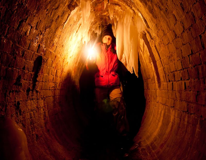
By the way, the tunnel was blocked almost full-height until 2008-2009. It was cleaned at some point and a small section near the portal was added. That’s the answer to the riddle of the Bryansk stream. I hope I haven’t disappointed anyone to whom I promised the story.
It is a cozy place, especially in the winter, when the icicles grow tall as a man.
The water supply network was large and didn’t limit itself to the water supply tracks. There’s a multitude of different branches. One of the noticeable structures is on the intersection with the Neglinka River. Who was inside can remember the part where the floor is washed out and the water level is higher. That is exactly the place where two old water supply tunnels go under the Neglinka.

According to the designs, the distance from the ceiling to the floor of Neglinka is some 50-60 cm. And the water pipes are above human height. It can happen that someday an explorer will fall into the water supply tunnel 🙂
Further development
Then came the revolution, and the communists became in charge. The city population continued to grow, new factories were built, and more water was required. The Mytishi and Roublev water supply together were not enough. The question of water supply was to be solved cardinally. A lot of hydrotechnical facilities were built in 1920-1930s. The Istrinslkoe reservoir was created, the Moscow-Volga channel was built, and many others. The Eastern water supply system and waterworks station was built soon after. The network was rapidly developing inside Moscow. That’s what we use till nowadays. Looking back from what we have today, the old water supplies look like toys. Can it be possibly imagined that the whole city was supplied with water by two steam engines of 26 h. p.?
The epoch of old water supplies ended in the beginning of the XX century. The epoch of cast iron pipes, brick galleries, aqueducts and buildings. A new era in water supply began, but this is another story 🙂
I shall end my story of historical water supply facilities here. It turned out to be long, but informative. Thanks to everyone who read it to the end! I’d like to add that not everything was found. Someone still might be lucky to find more preserved sections of Queen Catherine’s water supply or others, with a fresh look or an unusual approach to the subject.